Ambient Noise Tomography (ANT)
A low-cost and minimally invasive passive seismic imaging technique. Transform your mineral exploration strategy with 3D subsurface models up to 1-2 km deep.
What is ANT?
Ambient Noise Tomography (ANT) is a passive seismic imaging technique that utilises naturally occurring background vibrations from ocean waves, atmospheric disturbances, and human activities, to construct a 3D velocity model of the Earth's subsurface.
Unlike traditional active-source seismic methods that rely on explosives or Vibroseis trucks, ANT is entirely passive. This makes it a cost-effective and environmentally friendly alternative perfectly suited for early-stage, large-scale mineral exploration.
The Institute of Mine Seismology (IMS) has been pioneering the use of ANT for mineral exploration since 2015, successfully guiding exploration planning for clients globally, even in remote locations with thick overburden like in the Kalahari Copper Belt.

Compact, stand-alone wireless nodes are easily deployed in remote locations.
How It Works
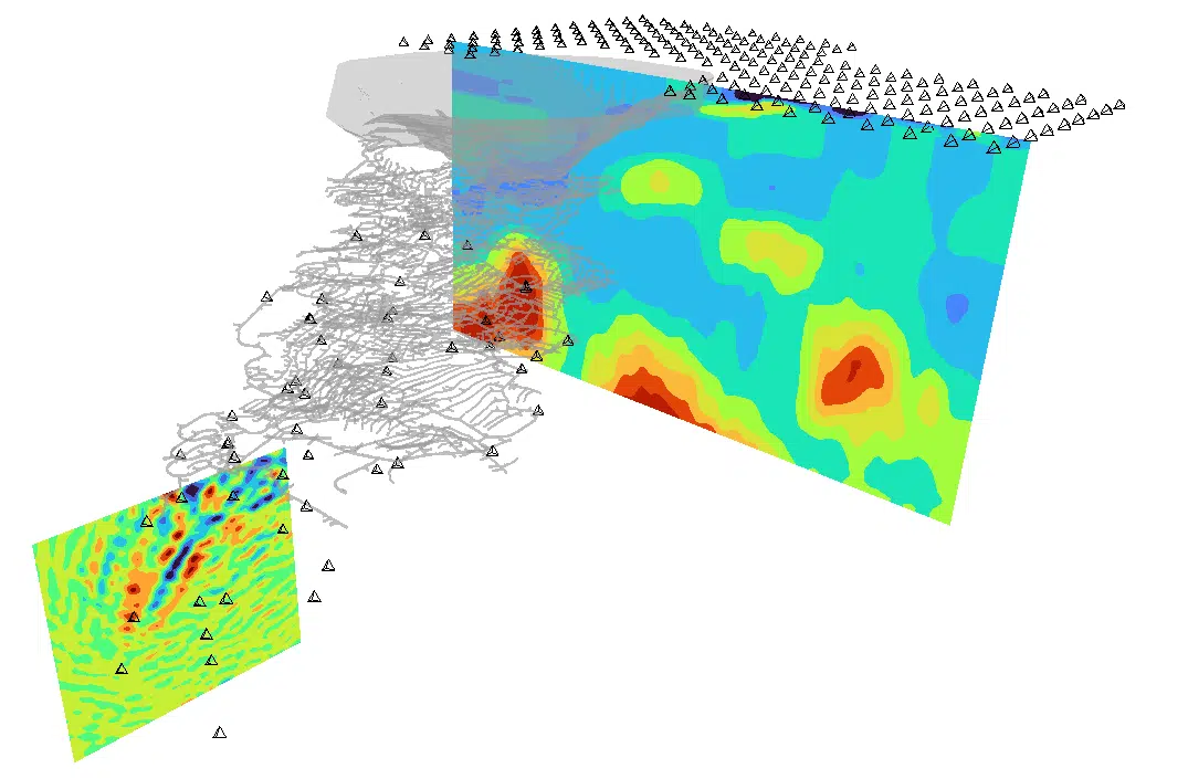
By recording continuous ambient noise with a temporary array of wireless seismic nodes, we can reconstruct the Green's function between sensor pairs through cross-correlation.
This allows us to extract surface wave dispersion characteristics. A changing velocity with depth is the reason for dispersion of surface waves. By inverting a large collection of these surface observations, we generate a 3D volume of shear-wave velocity (S-wave). Regions of anomalous seismic velocity can highlight potential drilling targets.
Advantages of Ambient Noise Surveys

Reduced Drilling Costs
Subsurface models from ANT inform intelligent drilling campaigns. By identifying specific areas of interest within large licence areas, you can eliminate wasteful expenditure. The cost of an entire ANT survey is often equivalent to just one or two deep boreholes.
Large Area Coverage
Nodes spaced 500 m to 800 m apart allow us to rapidly cover large areas up to 200 km², providing a comprehensive macro-view of regional geology.
Low Environmental Footprint
Surveys involve deploying compact, stand-alone wireless nodes buried in shallow holes. There is no need for heavy machinery, line clearing, or active sources, making it ideal for environmentally sensitive regions.
Rapid Deployment & Results
A moderately-sized survey typically utilises 100 to 300 wireless geophones deployed for a 25-day recording period. Shortly after node retrieval, processed data and 3D velocity models are ready for interpretation.
Applications of ANT
- Greenfields Mineral Exploration: Identify large-scale geological structures, faults, and stratigraphy at depth beneath extensive cover (e.g. Kalahari Copper Belt).
- Brownfields (Near-Mine) Exploration: Leverage existing in-mine seismic arrays combined with surface nodes to find near-mine drill targets.
- Tailings Storage Facilities (TSFs): Image internal weaknesses, track spatial velocity changes, and monitor internal erosion or leakage paths over time.
- Geotechnical Investigations: Sub-surface investigations prior to civil works, including void detection and bedrock mapping.

Trusted by Global Mining Leaders


Ready to Optimize Your Exploration Strategy?
From the Western Australian Gold Fields to the Canadian Shield, our team is ready to help you convert potential targets and regional hypotheses into drill-ready prospects.
Contact Our Geophysics Team❯